Saturday, June 5

Day 54- Old Inland Empire and Yakima Valley

93.7 miles- Richland to Selah, WA

Much of the beginning of today reminded me of my first day in Missouri Ozarks. The land was hilly and covered with vineyards. I found out tonight that this is one of the premier hop growing country in the United States.

With steadily gusting headwinds, I was on the bike for about ten hours today. I will have to finish this post when I have more energy. Seattle is so close.


Friday, June 4

Day 53- The Bombers

73.8 miles- Dayton to Richland, WA

Woke up this morning after a deep sleep induced by home-made IPA beer, had an energizing breakfast with Fred and Genie Crowe, and set off in pure sunshine for the first time in several days. The day was a chilling throwback to Kansas- flat fields of lush crops with industrial crop-sprayers lining the road (anyone know the actual name of these things?) After crossing a couple ridges, I rejoined the Snake River as it dumped into the Colombia River. I learned that hard winds blow from the Pacific and up the river valleys, making my day for more... exciting... than it otherwise would have been.

I resisted the urge to stop at the two breweries and several vineyards I passed on the way to the Tri-cities area (made up of the cities of Richland, Pasco, and Kennewick.) I was rewarded by spending all evening at a pizza/micro-brewery restaurant. I am staying with Rachael and her boyfriend Kacey who are graduate students currently working for the Pacific Northwest Laboratory. They were great people to stay with. Kacey made a keg-orator with wood paneling and molding, and four taps. He only fills this visionary piece of equipment with four different varieties of homemade beer.

The Tri-cities area was integral to the development of the bombs dropped in Japan during World War II. The people remain proud of their heritage and contribution to America's safety. Their high school team is known as the "Bombers"; streets are named Proton, Nuclear, and... drum roll... COSMIC; and there is a mural of a mushroom cloud in the public park.

Lastly, Kacey left dinner early to play in a hockey game. He got back and, as we drank his finely tailored Scotch Amber beer, attempted to explain and justify how he scored on his own goal during the game. We concluded it was the two hours at the microbrewery.


Wednesday, June 2

Day 52- Final Frontier

72.1 miles- Lewiston, Idaho to Dayton, Washington

What a relief to cross into Washington. Another cyclist rode past as I tried to set up my camera on a timer to get a picture in front of the state sign. He responded to my request to take the picture for me with "hell no!" Other than that, a rainy, but beautiful day. I climbed out of the river valley a few thousand feet into some desolate rolling countryside before entering the town of Dayton.


Day 51- Nez Pierce Indian Reservation

76.1 miles- Kooskia to Lewiston, ID

I dug down to the bottom of my right rear pannier to find something damp and dirty that hasn't seen the light of day since Kansas. With a high of 71 degrees, I wore short sleeves again! Even with on-and-off rain, the weather was amazing. I continued down the same river valley as yesterday. The valley remained narrow, opening only for the occasional field or Idaho main street.

The Nez Pierce Indian Reservation I went through belongs to the tribe of Chief Joseph who I wrote about while going through Big Hole. I visited the site of their creation story, known as the "heart of the beast." They believe that a beast lived in the Sweetwater River Valley that ate all the animals in the area. To put an end to this a coyote jumped down the throat of the beast and cut it up into pieces. The blood that splattered from this victory became the tribes in the plains. The coyote squeezed a few drops of blood from its heart and created the Nez Pierce.

Today I descended to below 1,000 feet for the first time since Kansas. Tomorrow I climb out of the river valley as the water goes south, and I head west.


Monday, May 31

Day 50- Another river valley

91.0 miles- Powell to Kooskia, ID

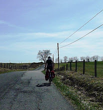
Last night I was pleased to read that the area in between the Bitterroot Mountains and the Sierras, the area I entered today, were protected by rain shadow. However, today, I followed the Selway river to Kooskia in constant light warm rain. The valley was narrow and the road followed along the bank of the river for every twist and turn. For about 70 miles there were no services and the road did not leave the river once. Instead of the valley opening into farmland and towns like in the Bitterroot, here the river widened and the banks remained narrow, with barely enough room for buildings.

I arrived in Kooskia to meet Laurie, a cyclist who leads bike tours for different companies. She has a second house in Kosskia and welcomes cyclists to stay. After showing me around, she trustingly left me to my own devices for the night. (I managed to do laundry for the third time during the trip, and the first since Colorado Springs.) I then met Tom and Therese Jessie Faller-Parrets parents, I think my biggest fans, for dinner. They began feeding me during rowing races over four years ago, and they now are meeting me in the middle of Idaho for much needed drinks- what a amazing people! The speciity of the restaurant was chicken fried steak, reminding me of the earlier days in the trip. Our waitress was so terribly efferfessant that we were not sure if she was going to offer us food or offer to share her pile of meth.

In case you missed the news, I changed the last leg of my route quite significantly from what I had planned originally. I am cutting out Oregon, and instead going through southern Washington via Dayton, Richland, Yakma, and then over the Sierra Mountains before heading north. I am about a week away from Seattle, my aunt and uncles place, and my daunting return to life.


Sunday, May 30

Day 49- Lolo Pass

85.7 miles- Hamilton, Montana to Powell, Idaho

Staying with Terry Tignor in Hamilton was like meeting twenty cyclists at once. Since she began to host cyclists last summer after her son biked from Virginia, she has had over 40 cyclists stay at her house. She recalled a Dutch couple who was cycling around the world continent by continent, a few groups of recent college grads, and a girl who rode a bike covered in tinsels and stickers with no maps. Talking to her has made up for the lack of fellow cyclists I have seen on the road.

As I continued down the Bitterroot Valley, the flatland in between the mountains grew from a width barely able to fit a main street to the several miles. Twenty miles before reaching the city of Missoula, I turned left to head over the Lolo Pass and into Idaho. The road again followed the Lewis and Clark Trail. After the explorers them came engineers hoping to cut a railway through the pass, but gave up, lamenting that this range was one of the most difficult they had come across. In 1995 a period of high winds devastated the area through the pass. While much of the dead wood was carted out for milling, the destruction remains obvious.

My first view of Idaho on the west side of the pass was stunning. The road spiraled precipitously downward towards a steep-bottomed gushing river. I made it down to a packed US Forest Service Campground fifteen miles after the pass. I am writing this listening to several distinct varieties of country music and a drunken fight.